Click here to see the SAS code.
Click here to see the example.
---------------------------------------------------------------
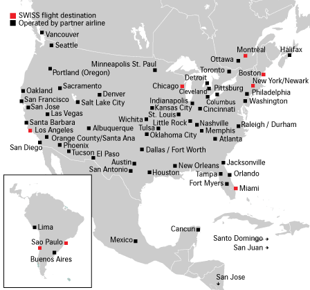
Recently, the 'strangemaps' website was poking fun at a Swiss Airlines map
which had terribly mis-aligned many American cities on their map...
(notice Pittsburgh is in a great lake, Portland & Sacramento
are much farther east than they should be, etc.)
Swiss Airlines on Strangemaps
 I'm not sure what software Swiss Airlines used to create that map,
but I decided to use SAS/Graph's "proc gmap" to create a new version of
the map, with 100% correct city locations (all programmatically calculated).
I'm not sure what software Swiss Airlines used to create that map,
but I decided to use SAS/Graph's "proc gmap" to create a new version of
the map, with 100% correct city locations (all programmatically calculated).
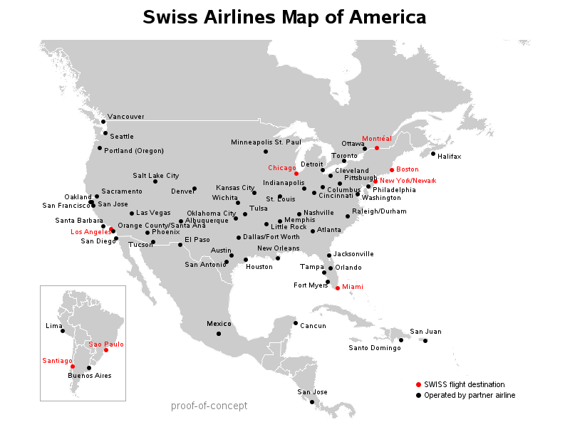 I use the 'worldcts' dataset (downloaded from the SAS mapsonline website)
to get the longitude/latitude of the cities, and then I "proc gproject"
these coordinates with the north-america (and south-america) sas maps
so that the coordinates line up in the exact right place.
I use "proc greplay" to do the small/inset South America map.
And I add html charttips & drilldown to the city names.
I use a few v9.2 features, such as annotate hsys='d' to specify text size
in points, and I use the "arial/unicode" character for a dot (because
that will make a nice smooth anti-aliased dot, whereas the sas software dot
would have jagged edges).
Back to Samples Index
I use the 'worldcts' dataset (downloaded from the SAS mapsonline website)
to get the longitude/latitude of the cities, and then I "proc gproject"
these coordinates with the north-america (and south-america) sas maps
so that the coordinates line up in the exact right place.
I use "proc greplay" to do the small/inset South America map.
And I add html charttips & drilldown to the city names.
I use a few v9.2 features, such as annotate hsys='d' to specify text size
in points, and I use the "arial/unicode" character for a dot (because
that will make a nice smooth anti-aliased dot, whereas the sas software dot
would have jagged edges).
Back to Samples Index